LOADING
…
Statistics towards Pacific:
Distance: 1851 km
Daily Average: 69 km
Days in the Area: 27
Days on the Bike: 17
Altitude covered: 16200 m
Daily Average: 955m
Nights in the Tent: 19
Nights in Houses: 8
Breakdowns: new middle Sprocket in the front, new Backtire
Daily Costs: 10,94€
…
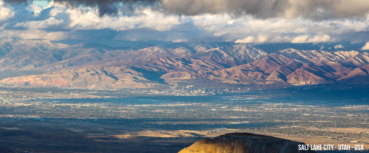
Salt Lake City was perfect to take a rest. pick up a parcel from Joshua with the maps for my future destinations in it Nad to organize a little bit.
I decided to leave the only day in the last weeks were it supposed to rain… clever!
After riding suburbs (with all that classical supermarket - Gasstation - fast-food Loop) almost half a day I reached out to the road that would lead me to the mountains. I planned to cross the Oquirrp Mountains over to Tooele and the road was really steep. First time since Thailand I had to put a stone under my back wheel to get a chance to pee. Crazy! Reaching the top of the Pass was just the beginning, I decided to go up to the Kennecott Mine View Point. The Mine is one of the few places you can see from the ISS and I wanted to see that in person. So I took the turnoff. But it was so steep and gravelly that i had to push the bike the most of the time… After 5km I reached the top and the View was incredible!
First cause of the panoramic view but mainly cause of the wind that blew ice cold over top. I pitched my tent with a little bit of Seeford and waited for the night. As I openenddiskussion the tent later a fully enlighten valley was shining up to me but the foreground was even more impressive. A worm of Trucks were winding up out of that 2000ft hole that the mine dogged into the mountain. A fabulous moving picture night. A guy told me that it´s cause the Hunting Season started that day. Additionally he called me nuts to sleep out there with temperatures around 10F. Mmmhh, I just smiled with a shrug…
The way down was horrible col d and bumpy. Fortunately I don’t had to push the bike down but my finger were painfully cold all the way down. As I realized down in Tooele on the other side of the ridge I lost my Bear bag with my food on my way down. Riding up again was not an option so I said farewell to my friend and went shopping.
North of Tooele there is the Great Salt Lake and the Golf courses all around here doesn´t really fit with the desert around us. As I learned later in California there is plenty of water in the ground its just salty. So the take the salt out with a complicated and expensive process and use it for Irrigation. Drinking water comes from the surrounding Mountains.
South of here the green was gone. Desert spreads left and right of the endless stretch of Asphalt that I followed. The landscape is dusty and spotted with bushes and you can see a few cattle from time to time.No glue what exactly they eat out here.
The only Shop that day let me stop over for a coke. I started a conversation with the shop owners Brian and his wife Jenny. At the end I stayed for two hours and even got an Invitation for Dinner. I cycled out into the desert absolutely happy and found a really nice camp spot not far away from the Highway.
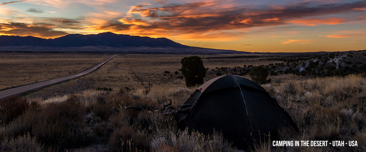
My goal was to reach the US Highway 50 that stretches from east to west through the great basin. This Basin is a Bowl without a drain so all the water (if there is any) is evaporating. Salty crusts left were Lake have been in the past. But it is not a plain, its divided in several valleys by ridges running from north to south. And the highway crosses all of them. So endless climbs and descents waiting for me… For me the road starts in Utah, exactly in Delta. From here there are a few stretches without any water and civilization for 2 or more days. So I took out my water bag and was happy that I didn’t send it back during my last sorting out… So I got enough food and 9L of Water to stand the heat and the loneliness of the great Basin.
The next days were wonderful, the landscape even it was empty wasn’t boring at all. The Solitude was refreshing, almost no cars on the road and the desert wasn’t moving at all. Unbelievable how peaceful that landscape is. Every time a valley started to get a little bit steady the climb into the next ridge started and on the other side there was something completely new. There is no water out here, the few farmers are herding cattles and have to dig deep wells for that.
Every night I had the difficult choice between thousands of nice places to pitch my tent, infinitely and dry bushy plains and always a Mountain ridge around me. Sunsets were breathtaking every evening and the nights were chilly but not really cold. Wonderful.
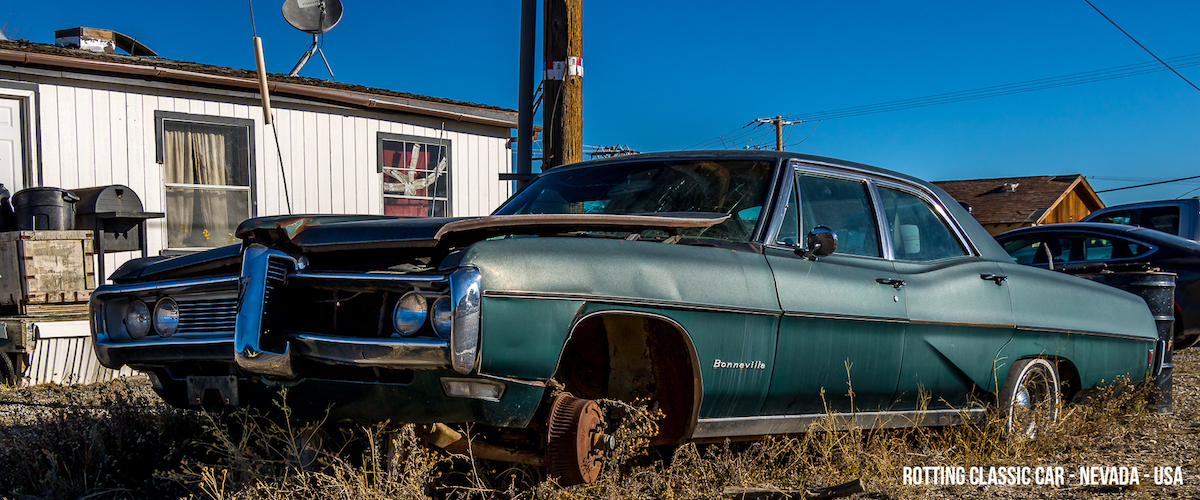
In Nevada the „loneliest road of America“ starts. A publicity stunt of the state but exactly what it is. Three settlements on the next 500km, just one of them a town and the others leftover of high times in the mining buissness. This is full of Charme.I really like the worn-down America you can find here at every corner.
Eleven days later I reached Fallon. Civilization was catching up with me again. The Navy is running their „Top Gun“ Programm out here so it is a lively little city full of shops, people and most of all: cars.
After that it gets greener. Irrigation Projects gave humidity and fertility back to the landscape and so I passed the first real lake since weeks. Nice to see that amount of water again. My next destination is Reno and rode up a hill to get there. I passed Virginia City, a historic Mining Town once one of the richest in America and now a Museum and National Monument. 140 Years ago they found one of the biggest vein of silver in history and the city grew drastically up to 20.000 citizens. There was no water up there and they had to bring the water from Lake Tahoe with a pipeline that is still working today. It is popular and most time very crowded. I was a little bit disappointed cause there was only main street and the incredible view. The street is full of old saloons and full of parking cars. This takes away a lot of the charme. I climbed the last few kilometers up to Geigers pass and then enjoyed the endless downhill into Reno.
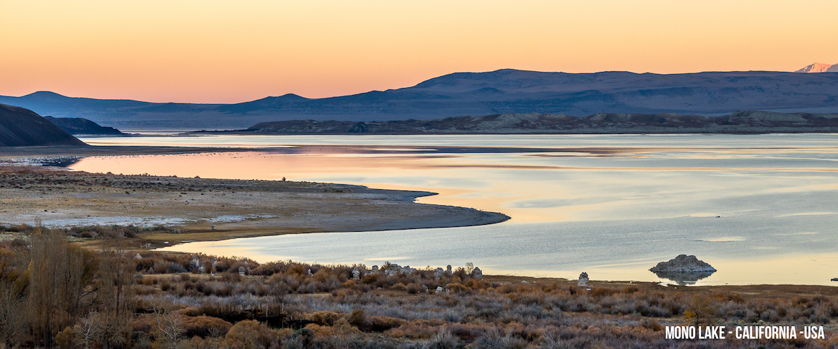
In Reno I met again Troy and MaryAnn. I stayed with them the last year and so it was very nice to see them again. I can’t stay long cause of the weather forecast. I wanted to cross the sierra Nevada next and snow was moving in from the east. Troy accompanied me for a hayride south and I stayed on the Eastside of the Sierra until I reached Mono Lake. The lake is wonderful. Salty and highly toxic it is shimmering in the waste land that is sorounding it. Acidic Springs in the ground of the Lake are producing chalk chimneys that are coming up with low water levels. Wonderful Landscape.
All the water that comes down from the mountains is disappearing in the Great Basin… Faszinating!
LA gets its water from the Sierra Nevada and the Colorado River and so the inflow into Mono Lake gets less and less. That lowers the level and makes the water even more salty and toxic… Decades ago it was a recreation area but now its dangerous to take a boat ride on it.
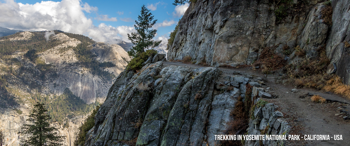
I rode up Tinga Pass the next day. The road leads directly into Yosemite National Park. Not a day early cause they closed it down for the season at the end of the day. The Pass road climbs up to 3100m and drops down very gently to the west. You cross high alpine meadows full of gigantic granite blocks and reach lower areas with forests and lakes… Beautiful landscape
I reached the Yosemite Valley, the heart of the Park, at the end of the day. It started being foggy and rainy on the Eastside so I couldn´t see anything in the valley that day.
As I opened my tent in the morning the view was impressive. 1000m high vertical rocks surrounded me. I walked around and found beautiful streams, oak forests and a peaceful valley green as not seen for a while…
The Valley is a Mecca for climbers, I came in Off Season and not a lot were around. It takes a lot to climb a wall like the legendary El Capitan that is 1000m high. I got my pants full just looking up to it.
Cause the weather wasn’t that nice I rested for a few days, but one day I decided to leave the valley hiking up into the Mountains. There is a point up there called glacier point, normally crowded cause they build a road up there. These days the road was closed and just a few took the 4 hours hike to reach the rim. From there an don the way up there you have incredible views of the valley. When you reach the top you got a fantastic view of Halfdome. I decided to go even further up and reach Sentinel Dome. From there you have a open panoramic view of the whole valley and even big parts of the park. The glaciers created soft shapes and the round rocks are definitely a view. With 1500 vertical meters of climb this was also my peak project for north america. I really wished I could have taken something more challenging but the season was always against me. The descent lasted for hours and as I reached the tent I barely couldn’t even walk anymore. Always going for the extreme… that I did that with my cycling shoes on wasn’t really helpful at all.
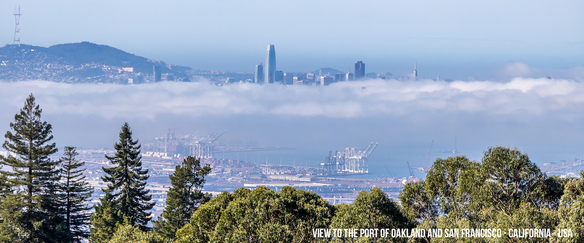
A Day of rest and I got back on my bike. A painful climb out of the Valley later I reached the totally sunburnt yellow San Joaquin Valley. The Valley is the main agricultural place in California and so I passed gigantic fields of grapes, Oranges, Citrons and vegetables. A lot of cattle and people were also around and with this the dirt and the pollution came. The rivers were full of rubbish and far away from the clear streams I seen up in the mountains… I passed it quickly and cycled into the Diablo Range.On the other side there is the San Francisco Bay also called the Bay Area. I chose the nicest and most winding road and that brought me directly up to the highest peak of the range Mount Hamilton. The climb was one of the steepest I ever made and reaching the top was a relief. My legs were hurting. I expected a panoramic view of the Bay but it was foggy up there. The telescopes were appearing out of the clouds and the sun was pushing through… I found a nice place to camp along the road down in the middle of oak trees.
The descent the next day was fantastic. A endless winding road brought me down through oak forrest and wineries into the foothills near San Jose. In the Hills you can see a lot of rich properties overlooking the lively city in the valley. Always faszinating to see it separating like that…
This day I was cycling through the Cities of the Valley, I crossed Fremont with the Tesla Factory and next to it the workers unions office fighting for fair wages and better work conditions…
The closer I got to Oakland the more wore down the area got. More and more Homeless people on the streets and some areas are really fucked up. I reached Oakland in the evening and stayed with Tiff for a few days. I cycled a little bit around the town and the surrounding areas but mainly I rested…
But finally I crossed the Bay on a boat and reached San Francisco. I really wanted to finish that part of the trip and start a new one. It took me a little bit more than 4 months, 140 days and 10.400km to cross the USA (and a little bit of Canada) to get here. What a ride.
Now I’m ready to ride along the coast south to reach my next Adventure: Mexico!
What I experienced along the Californian coast I will tell you the next time…
I decided to leave the only day in the last weeks were it supposed to rain… clever!
After riding suburbs (with all that classical supermarket - Gasstation - fast-food Loop) almost half a day I reached out to the road that would lead me to the mountains. I planned to cross the Oquirrp Mountains over to Tooele and the road was really steep. First time since Thailand I had to put a stone under my back wheel to get a chance to pee. Crazy! Reaching the top of the Pass was just the beginning, I decided to go up to the Kennecott Mine View Point. The Mine is one of the few places you can see from the ISS and I wanted to see that in person. So I took the turnoff. But it was so steep and gravelly that i had to push the bike the most of the time… After 5km I reached the top and the View was incredible!
First cause of the panoramic view but mainly cause of the wind that blew ice cold over top. I pitched my tent with a little bit of Seeford and waited for the night. As I openenddiskussion the tent later a fully enlighten valley was shining up to me but the foreground was even more impressive. A worm of Trucks were winding up out of that 2000ft hole that the mine dogged into the mountain. A fabulous moving picture night. A guy told me that it´s cause the Hunting Season started that day. Additionally he called me nuts to sleep out there with temperatures around 10F. Mmmhh, I just smiled with a shrug…
The way down was horrible col d and bumpy. Fortunately I don’t had to push the bike down but my finger were painfully cold all the way down. As I realized down in Tooele on the other side of the ridge I lost my Bear bag with my food on my way down. Riding up again was not an option so I said farewell to my friend and went shopping.
North of Tooele there is the Great Salt Lake and the Golf courses all around here doesn´t really fit with the desert around us. As I learned later in California there is plenty of water in the ground its just salty. So the take the salt out with a complicated and expensive process and use it for Irrigation. Drinking water comes from the surrounding Mountains.
South of here the green was gone. Desert spreads left and right of the endless stretch of Asphalt that I followed. The landscape is dusty and spotted with bushes and you can see a few cattle from time to time.No glue what exactly they eat out here.
The only Shop that day let me stop over for a coke. I started a conversation with the shop owners Brian and his wife Jenny. At the end I stayed for two hours and even got an Invitation for Dinner. I cycled out into the desert absolutely happy and found a really nice camp spot not far away from the Highway.
My goal was to reach the US Highway 50 that stretches from east to west through the great basin. This Basin is a Bowl without a drain so all the water (if there is any) is evaporating. Salty crusts left were Lake have been in the past. But it is not a plain, its divided in several valleys by ridges running from north to south. And the highway crosses all of them. So endless climbs and descents waiting for me… For me the road starts in Utah, exactly in Delta. From here there are a few stretches without any water and civilization for 2 or more days. So I took out my water bag and was happy that I didn’t send it back during my last sorting out… So I got enough food and 9L of Water to stand the heat and the loneliness of the great Basin.
The next days were wonderful, the landscape even it was empty wasn’t boring at all. The Solitude was refreshing, almost no cars on the road and the desert wasn’t moving at all. Unbelievable how peaceful that landscape is. Every time a valley started to get a little bit steady the climb into the next ridge started and on the other side there was something completely new. There is no water out here, the few farmers are herding cattles and have to dig deep wells for that.
Every night I had the difficult choice between thousands of nice places to pitch my tent, infinitely and dry bushy plains and always a Mountain ridge around me. Sunsets were breathtaking every evening and the nights were chilly but not really cold. Wonderful.
In Nevada the „loneliest road of America“ starts. A publicity stunt of the state but exactly what it is. Three settlements on the next 500km, just one of them a town and the others leftover of high times in the mining buissness. This is full of Charme.I really like the worn-down America you can find here at every corner.
Eleven days later I reached Fallon. Civilization was catching up with me again. The Navy is running their „Top Gun“ Programm out here so it is a lively little city full of shops, people and most of all: cars.
After that it gets greener. Irrigation Projects gave humidity and fertility back to the landscape and so I passed the first real lake since weeks. Nice to see that amount of water again. My next destination is Reno and rode up a hill to get there. I passed Virginia City, a historic Mining Town once one of the richest in America and now a Museum and National Monument. 140 Years ago they found one of the biggest vein of silver in history and the city grew drastically up to 20.000 citizens. There was no water up there and they had to bring the water from Lake Tahoe with a pipeline that is still working today. It is popular and most time very crowded. I was a little bit disappointed cause there was only main street and the incredible view. The street is full of old saloons and full of parking cars. This takes away a lot of the charme. I climbed the last few kilometers up to Geigers pass and then enjoyed the endless downhill into Reno.
In Reno I met again Troy and MaryAnn. I stayed with them the last year and so it was very nice to see them again. I can’t stay long cause of the weather forecast. I wanted to cross the sierra Nevada next and snow was moving in from the east. Troy accompanied me for a hayride south and I stayed on the Eastside of the Sierra until I reached Mono Lake. The lake is wonderful. Salty and highly toxic it is shimmering in the waste land that is sorounding it. Acidic Springs in the ground of the Lake are producing chalk chimneys that are coming up with low water levels. Wonderful Landscape.
All the water that comes down from the mountains is disappearing in the Great Basin… Faszinating!
LA gets its water from the Sierra Nevada and the Colorado River and so the inflow into Mono Lake gets less and less. That lowers the level and makes the water even more salty and toxic… Decades ago it was a recreation area but now its dangerous to take a boat ride on it.
I rode up Tinga Pass the next day. The road leads directly into Yosemite National Park. Not a day early cause they closed it down for the season at the end of the day. The Pass road climbs up to 3100m and drops down very gently to the west. You cross high alpine meadows full of gigantic granite blocks and reach lower areas with forests and lakes… Beautiful landscape
I reached the Yosemite Valley, the heart of the Park, at the end of the day. It started being foggy and rainy on the Eastside so I couldn´t see anything in the valley that day.
As I opened my tent in the morning the view was impressive. 1000m high vertical rocks surrounded me. I walked around and found beautiful streams, oak forests and a peaceful valley green as not seen for a while…
The Valley is a Mecca for climbers, I came in Off Season and not a lot were around. It takes a lot to climb a wall like the legendary El Capitan that is 1000m high. I got my pants full just looking up to it.
Cause the weather wasn’t that nice I rested for a few days, but one day I decided to leave the valley hiking up into the Mountains. There is a point up there called glacier point, normally crowded cause they build a road up there. These days the road was closed and just a few took the 4 hours hike to reach the rim. From there an don the way up there you have incredible views of the valley. When you reach the top you got a fantastic view of Halfdome. I decided to go even further up and reach Sentinel Dome. From there you have a open panoramic view of the whole valley and even big parts of the park. The glaciers created soft shapes and the round rocks are definitely a view. With 1500 vertical meters of climb this was also my peak project for north america. I really wished I could have taken something more challenging but the season was always against me. The descent lasted for hours and as I reached the tent I barely couldn’t even walk anymore. Always going for the extreme… that I did that with my cycling shoes on wasn’t really helpful at all.
A Day of rest and I got back on my bike. A painful climb out of the Valley later I reached the totally sunburnt yellow San Joaquin Valley. The Valley is the main agricultural place in California and so I passed gigantic fields of grapes, Oranges, Citrons and vegetables. A lot of cattle and people were also around and with this the dirt and the pollution came. The rivers were full of rubbish and far away from the clear streams I seen up in the mountains… I passed it quickly and cycled into the Diablo Range.On the other side there is the San Francisco Bay also called the Bay Area. I chose the nicest and most winding road and that brought me directly up to the highest peak of the range Mount Hamilton. The climb was one of the steepest I ever made and reaching the top was a relief. My legs were hurting. I expected a panoramic view of the Bay but it was foggy up there. The telescopes were appearing out of the clouds and the sun was pushing through… I found a nice place to camp along the road down in the middle of oak trees.
The descent the next day was fantastic. A endless winding road brought me down through oak forrest and wineries into the foothills near San Jose. In the Hills you can see a lot of rich properties overlooking the lively city in the valley. Always faszinating to see it separating like that…
This day I was cycling through the Cities of the Valley, I crossed Fremont with the Tesla Factory and next to it the workers unions office fighting for fair wages and better work conditions…
The closer I got to Oakland the more wore down the area got. More and more Homeless people on the streets and some areas are really fucked up. I reached Oakland in the evening and stayed with Tiff for a few days. I cycled a little bit around the town and the surrounding areas but mainly I rested…
But finally I crossed the Bay on a boat and reached San Francisco. I really wanted to finish that part of the trip and start a new one. It took me a little bit more than 4 months, 140 days and 10.400km to cross the USA (and a little bit of Canada) to get here. What a ride.
Now I’m ready to ride along the coast south to reach my next Adventure: Mexico!
What I experienced along the Californian coast I will tell you the next time…